
Great stories depend on a great world
Tamora Pierce spins a great yarn without telling you all of Tortall’s history while Terry Brooks does go on a bit, but manages to tell his story without writing a treatise. The stories that stick with us are the ones that we can connect with.
That’s why I play RPGS: I get to tell stories that connect me to my friends.
Not every session needs as much backstory as the Forgotten Realms, and even within detailed world you can choose your level of elaboration and preparation. Whether you’re running a one-shot or are embarking on a long campaign, world-building is part of the joy.
I don’t think I’m alone in my love of diving into the details of a campaign setting..
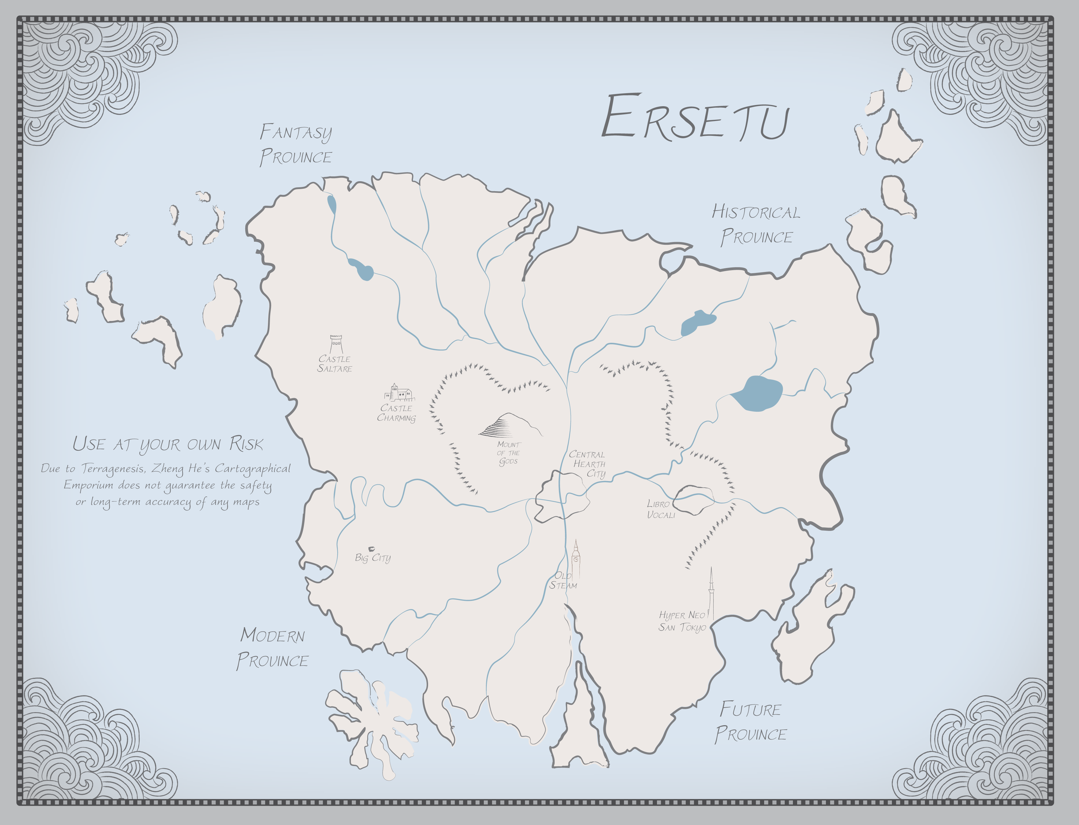
For me, Cartography is a large part of worldbuilding. The shape of the world determines the lives of the people in it and the terrain shapes history, roads shape and are shaped by economics, geography and biosphere shape a culture’s development. A good map is as much a part of the story of a world and a people as its history.
How do we make good maps? If you’re new to the world of tabletop roleplaying games, mapmaking can be daunting. The key point to remember is that the best map, and by extension the best mapmaking technique, is the one that informs your game. If what you’ve created doesn’t inform your players’ experience, it isn’t important. If you spend hours on the map and that investment of time helps you build a better story, it’s time well spent. I’ll make a brief plug here for Michael Shea’s The Lazy Dungeon Master. This book helped me refine my style of play when leading games, and my emphasis on preparing only what is necessary is inspired in part by that book.
Making Maps Accessible
One of the primary goals of the Emerald City Game Masters Guild is running games for everyone. Inclusivity isn’t just about subject matter or the rules of the table; it’s also about making the game materials accessible. When you’re creating a map, think about contrast, font, and format. Don’t assume that everyone will experience the map in the same way. Make it easy for your players to read, refer to, print and interact with the map. Contrast ratio tools are often used by web and UX designers to ensure that their color choices are readable, and this guide will help you decide which font is right for your cartography.
Inkarnate
Why reinvent the wheel? Inkarnate is a web-based tool for creating beautiful fantasy maps. The free version is more than enough for my needs, and I think for most GMs. There are pro plans for those who need or want a little more. Maps can be created at large or small scales, and the stock assets look great. If you’re not in need of a lot of customization, or need something on the quick and cheap, Inkarnate is a great option.
The Raster Graphics Editor of Your Choice
If you want to build your own detailed maps, photo editing or raster graphics software is the way to go. The Lord High and Mighty of Raster Graphics Editors is Photoshop, of course, and Adobe’s Creative Cloud platform has made it slightly less wallet-crushing to use. It isn’t the only option: GIMP is an open source option that is free, period.
Hard to beat that price.
This tutorial has served me well for years. It is skewed heavily toward an older version of Adobe’s Photoshop, but I’ve found that it can be translated to newer versions and other software. The tutorial is clearly written and is a great starting point. You can tweak the method to apply to different scopes, either a small valley or a whole continent. It takes a bit of practice but is well worth the effort.
Drawing Pretty Lines with Vector Graphics Editors
Where tools like Photoshop excel at fine details and polish, Vector Graphic Editors like Adobe’s Illustrator and Inkscape (Hosted by the Oregon State Open Source Lab) excel at creating lines and shapes. It’s easy to create your own legends and even create brushes with simple shapes that repeat along a given path.
If you’re not familiar with vector-based art, think in terms of lines connecting points. You can start by creating the outline of your territory with a pen tool. Roads, streams, and other features can be represented in different colors. These tutorials will show you how to take shapes and repeat them along a path, letting you build mountains, forests, and other terrain. You can do the same with stamp tools.
The Old Ways
There is something satisfying about working on paper. This can be as simple as a #2 pencil and a sheet of notebook paper, or you can invest in stationery and a variety of writing instruments.
My personal preference is to start with graph paper and a light sketching pencil. I’ll sketch out the rough outline of a space, add some basic features and arrange terrain and landmarks. Using a light pencil will help you refine your creation later. If you plan on scanning the image, try using a blue pencil or blue leads in a mechanical pencil. You can easily remove blue color from an image after scanning it.
Think carefully about elevation, the flow of water, and biosphere. Rivers cut paths into stone. Lowlands can collect water. Mountains can split a territory into dry and wet climates. You don’t have to determine all of this right away, just start sketching out ideas.
Once you have sketched out your basic map, start to fill in the details. Maybe a section of coastline has fjords. That river there might broaden and curve back on itself when it hits the plains. You can look at detailed maps of real coastlines, mountains, and other biomes for inspiration. The United States Geological Survey is a great resource for detailed maps. Take your time and don’t be afraid to experiment.
What you do with the final product is up to you. My preferred method is to use tracing paper to copy the finished piece in pen. If you used a light pencil, you can trace over your work with fine-tipped markers and erase the pencil lines as you go. As I mentioned above, you can scan in the result and edit out grid lines or extra pencil lines. Blue pencil leads come in handy, because you can remove the color from a scanned image and leave the darker lines.
My preferred drawing kit includes:
- Palomino Blackwing Pencils
- Pentel GraphGear mechanical pencils
- Straightedge with scale measurements Vinyl Erasers Staedler pigment liners in .1, .3, .5, and .7 sizes Sharpener or small pocketknife Chaotic Neutral Ground: Random Generators I’ve been known to throw together a session without preparation, and that’s when random generators come to the rescue. There are a number of good programmatic options for creating cities and worlds out there. Donjon is my personal favorite for rapid random generators, and there are many other options out there.
Chaotic Stupid: Let the Dice do the Talking Sometimes, you just need to let the dice do the work. What’s Over the Horizon If you find yourself enjoying speculative cartography for its own sake, you’re not alone! The Cartographer’s Guild forum is a good resource, as are reddit’s r/mapmaking and r/WorldBuilding. As with any forum or online community, remember not to feed the trolls.